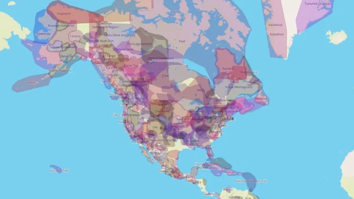
Within North America and many other regions colonized by Europeans, the Indigenous territorial borders that once divided the land have largely disappeared. Though non-Native people might learn about the particular groups that once lived in their immediate area in school, most of us aren’t aware of the exact geography of which areas were traditionally occupied by which groups across the U.S. and the world. A mapping project called Native Land aims to change that.
The interactive site was created by Canadian mapping specialist Victor Temprano, who grew up within the territory of the Okanagan People in British Columbia. It features several different ways to explore the boundaries of Indigenous history: through territory, language, and historic treaties. Each of the colorful blobs that represent the approximate boundaries of each territory, language, or treaty contains a link that lets you further explore the area, linking out to tribes’ websites, government information about particular treaties, and more.
The map allows you to see the huge diversity of Indigenous people whose history colonists have often erased, and the overlaps between tribes and languages in different areas. While the map doesn’t yet tackle the entire world, it has a wealth of information on the Americas, New Zealand, and Australia, and some places in Europe and Africa.
Temprano doesn’t claim Native Land is a definitive guide—or even a complete one—and welcomes any community feedback on the content presented. In 2018, he told Atlas Obscura that he has gotten thousands of emails over the years suggesting changes, and has worked to incorporate that information into the map.
“I’ve learned that the idea of ‘traditional territory’ is actually very slippery. It can mean a strongly defined official boundary (Squamish nation, for instance), a general sense of land familiarity or habitation (some Métis people), a historically inhabited area, or it can be shorthand for how people identify themselves,” he wrote on the Native Land blog in 2018. “Above all, I’ve tried to make the territory layer about self-identification. Whenever people feel they or their peoples are not represented, I’ve attempted to add them … So approach the layer with caution, and don’t treat it as an academic set of truths—if you can help it. It’s a good place to get started, but it’s really about you taking the initiative to learn more and think carefully about these questions.”
A version of this story originally ran in 2018; it has been updated for 2023.
This article was originally published on www.mentalfloss.com as This Website Allows You to See the Traditional Indigenous Territories and Languages in Your Region.